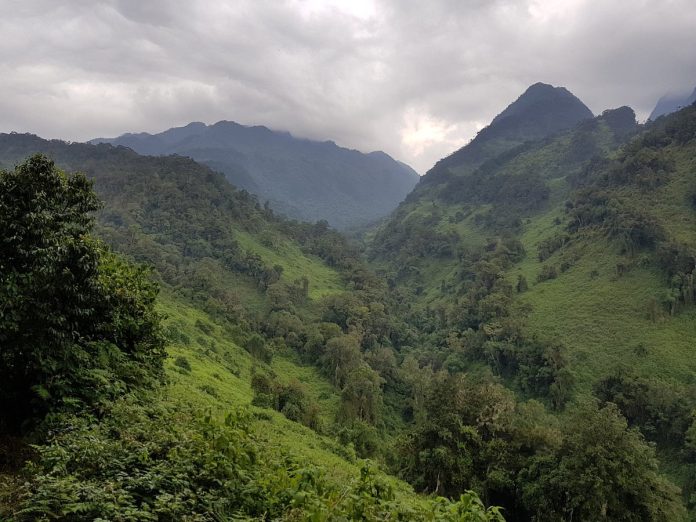
The Rwenzori mountains are found in the western Uganda in the eastern arm of rift valley extending across the Democratic Republic of Congo and Virunga National Park. The Rwenzori mountains also known as Rwenjura or Rwenzururu are ranges of mountains with 6 peaks separated by gorges for instance; Mount Luigi di Savoia 4,627m, Mount Gessi 4,715m, Mount Emin 4,798 m, Mount Baker 4,843m, Mount Speke (4,890m), and Mount Stanley at 5,109m. Mount Stanley has other minor peaks, with Margherita being the highest peak making it the third highest in Africa. The upper regions of these ranges are permanently snow-capped and glaciated.
These mountains are located in Rwenzori Mountain National park that covers an area of 996 sq kms with rocky outcrops, lakes, cliffs, and different vegetation zones. The park was gazetted and recognised as a World heritage site in 1991. Later in 2008 the protected area was recognized as a Ramsar site. Hiking the Rwenzori mountains takes from 7 to 12 days to complete the trek to the peak depending on the routes one uses. There are other itinenaries for instance 9 days mountain Rwenzori hiking. These treks go through the Bakonzo villages.
The Rwenzori Mountains have different hiking routes, each providing a unique experience with different attractions along the way. Some of these hiking trails include:
The Central Circuit Trail is the shortest and most popular old tracking route used by mountaineers to Margherita peak. The trail starts from Mihunga gate and passes through Bukuju via John matte and Nyabitaba. Then the trail leads to other peaks to the scott elliot pass to lake Kitandara, Elena Glacier and Bujuku valley. Further it navigates through different vegetation zones that offer views of Mount stanley, Mount speke and the weismann peak. The trail crosses the lower and upper bigo bogs which support the boardwalks in the area. Also the route follows thick forests that are habitat to different mammal and bird species. For Instance; forest elephants, forest buffaloes, hyraxes, L’Hoest monkeys, black and white colobus monkeys while birds include; handsome francolin, strange weaver, barred long tailed cuckoo, and Rwenzori Turaco. Along the way there are distributed huts that are used for overnight stays by the Mountaineers. These huts are weather condition tolerant. The safaris along this trail typically takes around 6 to 7 days to complete depending on one’s strength and preference. The central circuit trail is managed by Rwenzori mountaineering service owned by the locals around Rwenzori mountains.
The Kilembe Trail also known as the southern circuit located 14 km west of Kasese municipality and managed by the Rwenzori Trekking service (RTS). The trail starts from the town of Kilembe and passes through lush montane forests, bamboo zones, and alpine. It also follows the combination of trails along the Kamusoni, Nyamugasani and Nyamwamba river valleys. Professor Scott Elliot first discovered this route in 1895 before Luigi di Savoia had developed another route from Nyakalengija via the Bujuku valley. Using the Kilembe trail the hiking distance to the peak is longer compared to when one has used a central circuit. Being the longest route, Kirembe trail offers climbing experience and views of glaciers, lake Muhoma as well as flora and fauna. This will also lead to pushing the excursion for more days.
Lake Mahoma Trail is another alternative to the central circuit and was opened in 2012. The route is short and more wildlife oriented. Mountaineers hike from Nyakalengija trail at an altitude of 2088m into bamboo forest where the glacial lake Muhoma offers a view of the high peaks. The trail takes 2 to 3 days to complete and offers scenic views of waterfalls, rivers, and dense forests. Tourists are able to see different mammal species along the way like L’Hoest monkeys, blue monkeys, black and white colobus monkeys, forest elephants and forest buffoles. The trail is suitable for hikers of all fitness levels and provides opportunities for cultural encounters with local communities.
The Bukunguru trail was developed after the central circuit and Kilembe trail. The trail is mostly used by wild nature enthusiasts and those who like camping. Along the route there are four lakes for instance; Irene, Bujuku, Mughuli and Bukunguru. These are accompanied by the mountain rivers and waterfalls. This trail takes 8 days to complete or to reach Margherita peak. There are no huts though having safe organized areas and all the routes on this trail are managed by the Bujuku eco tours.
However as of May 14 2024, Uganda Wildlife Authority temporarily suspended hiking activities to Margherita peak in Rwenzori National park. The organization came up with the decision of installing a permanent ladder on the right side of Margherita glacier as precautionary measure for the crevasse formation in the Margherita glacier. This alternative route offers secure passage for hikers
Best time to climb Rwenzori mountains
Climbing Rwenzori mountains can be done any time around the year, although the best time to climb is during the dry seasons that occur from June to August and December to February. During these months, the weather is generally more stable with lower chances of rainfall and tourists are able to see Rwenzori mountain at its finest. During the months of December to February the weather tends to be steady with warm days and cold nights. Tourists in these months are able to climb up to the peak and summit the margherita. Also this short period of time offers tourists an opportunity to see Rwenzori mountains at their best.
Mountain Rwenzori national park is visited more often during these months of dry season and tourists get the opportunity to enjoy the chilly weather around the mountains. However, the Rwenzori Mountains can experience rainfall at any time of the year due to their proximity to the equator. Even during the dry seasons, it can drizzle and tourists should be prepared for variable weather conditions regardless of when you choose to climb.
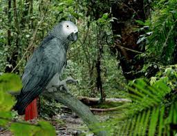
A new African Grey Parrot conservation center has opened at the Uganda Wildlife Education Centre in Entebbe. The facility was established with funding from the Japanese International Cooperation Agency (JICA) and Chubu University in Japan. Its primary purpose is to support research on African gray parrots, promote eco-tourism, and contribute to education and the local economy.
Many people’s interactions with parrots have been limited to seeing them in cages. Parrots and parakeets are popular pets in households worldwide because of their unique ability to mimic sounds and their colorful plumage. However, the demand for these intelligent birds has led to widespread capture and captive breeding to supply the global pet market.
Exotic species like the African gray parrot are particularly sought after due to their high intelligence, which ranks among the highest in the animal kingdom, alongside apes and cetaceans. Their remarkable ability to mimic voices and solve problems has contributed to their popularity.
The conservation center aims to raise awareness about the importance of preserving African gray parrots and their natural habitat. Through research, education, and eco-tourism initiatives, it seeks to promote conservation efforts and ensure the long-term survival of these fascinating birds.
The African gray parrot, also known as the “world’s most traded bird,” has been listed as endangered by the International Union for Conservation of Nature due to a significant decline in numbers, particularly in western and central African rainforests, largely because of poaching. Uganda, with its tropical forests, is one of the habitats for these parrots. Since the 1970s, over 1.2 million African gray parrots have been traded globally.
The hunting of African grays from the wild has severely harmed their population. Additionally, the extensive trade has raised concerns about biosecurity. Recently, the Wildlife Trust of India’s enforcement team uncovered an illegal trade racket involving African gray parrots. This highlights the urgent need for conservation efforts to protect these birds and their habitats.
According to the UWEC Manager for Education and Information, the new facility will enhance the center’s efforts to become a focal point for African gray parrot conservation. Additionally, it will serve as a training center for communities to learn about conserving this endangered bird species.
This represents a modern approach to tourism, aiming to benefit local communities through various livelihood enterprises such as homestays, birding, and forest walks, which are popular among tourists visiting bird communities. The goal is to empower communities residing in areas where these parrots are found. Islands like Ngamba and Koome are expected to benefit from these initiatives.
In addition to the African gray parrot, the Uganda Wildlife Education and Conservation Center is home to a variety of birds. These include the African fish eagle, Pink-backed Pelican, peacock, ostrich, and gray crowned crane.
The Toro Semliki Wildlife Reserve sits in the western region of Uganda, spanning across Ntoroko and Kabarole districts. Originally established as a game reserve in 1926, it covers an area of 542 square kilometers. The reserve is set in a striking rift valley landscape, nestled between the Rwenzori Mountains, Kijura Escarpment, and Lake Albert. It holds particular appeal for bird-watchers due to its diverse avian population. With an impressive checklist, the reserve boasts many birding specials, including species endemic to the Albertine Rift.
Climate and weather
The climate in Toro-Semliki Wildlife Reserve is consistently hot throughout the year. Daytime temperatures hover around 30°C/86°F, while nighttime temperatures drop to about 18°C/64°F. Unlike some other places, Toro-Semliki does not have a distinct dry season. Instead, rain can occur unpredictably at any time. However, the area experiences two distinct Wet seasons: one from March to May and another from August to November.
Vegetation of Toro Semliki Wildlife Reserve
The dominant vegetation type in the wildlife reserve is open acacia-combretum woodland and grassy savannah. This landscape is punctuated by patches of Borassus palm forest, extensive belts of riparian woodland along the main watercourses, and large swamps near Lake Albert. Although the reserve itself does not boast remarkable topography, sitting at a relatively low altitude of around 700 meters above sea level, on clear days, visitors can enjoy breathtaking views. To the east, the Rift Valley escarpment rises sharply from the shores of Lake Albert, while the 2500-meter-high Congolese Blue Mountains grace the western horizon. Additionally, the glacial peaks of the Rwenzori Mountains are visible to the southwest, adding to the scenic beauty of the reserve.
Wildlife in Toro Semliki Wildlife Reserve
Toro-Semliki National Park is home to many of the same major species found in Queen Elizabeth and Murchison Falls National Parks. Among these are warthogs, elephants, waterbuck, buffalo, Uganda Kob, giant forest hogs, and hippos. Additionally, the park hosts a variety of primates, including chimpanzees, red-tailed monkeys, baboons, black and white colobus monkeys, and vervet monkeys.
One notable feature of the elephant population in the reserve is its diversity, comprising both savannah and forest elephants, as well as a hybrid type resulting from inbreeding. This unique aspect adds to the richness of wildlife experiences available to visitors exploring Toro-Semliki National Park.
Activities done in Toro Semliki Wildlife Reserve
Birding
Toro-Semliki Wildlife Reserve is a home for approximately 460 bird species. Birdwatching enthusiasts can enjoy their hobby in the morning or afternoon, with opportunities to spot a variety of avian treasures. Among the notable species that can be sighted are the elusive shoebill stork, the vibrant red-throated bee eater, the striking Luhders Bushrike, the exquisite Tropical Boubal, the distinctive Black-billed Barbet, the majestic Abyssinian Ground-hornbill, the Arrow-marked Babbler, the elegant Black-headed Bushshrike, and the agile Red-necked Falcon.
These birds can be observed during nature walks or boat rides on Lake Albert. Moreover, from November to April, the reserve welcomes migratory birds, enhancing the diversity of avifauna. Due to its proximity to Semliki National Park, visitors also have the opportunity to encounter various Congolese rainforest species, enriching the birdwatching experience in Toro-Semliki Wildlife Reserve.
Boat ride on Lake Albert
Two boat cruises are available on Lake Albert, one at dawn and another at sunset, primarily sought after by birdwatchers eager to spot the elusive shoebill stork. These majestic birds often conceal themselves among the papyrus and weeds along the marshy shorelines. Additionally, bird enthusiasts may have the opportunity to observe other avian species such as the African Pygmy Goose, Blue-breasted and Blue-cheeked Bee-eaters, and Blue-headed Coucal.
The morning boat safari, considered the highlight of the experience, is offered by lodges and the wildlife reserve.
Primate walk
The chimpanzee population in Toro Semliki Wildlife Reserve is of particular scientific interest because they inhabit a drier environment compared to those in Kibale, Budongo, or Kyambura. This means they must travel longer distances to find food and have been observed walking on their hind legs for short distances.
During the chimpanzee trekking, which typically lasts 3–4 hours, you will be accompanied by a ranger guide who will lead you through riparian and acacia woods, Borassus palm forests, and savannah grasslands. It’s important to note that chimpanzees in this area are less habituated compared to those in other habitats.
In addition to chimpanzees, visitors may also encounter other primate species such as vervet monkeys, black and white colobus monkeys, red-tailed monkeys, and olive baboons.
Hiking Nyaburogo gorge
The hike begins at the park headquarters and covers a distance of 7km, leading through diverse habitats such as savanna grassland, woodland, and a forest in the gorge. This trail is popular among birdwatchers, offering opportunities to spot various bird species including the Luhdrers Bushrike, Tropical Boubal, Black-headed Bushshrike, and Arrow-marked Babbler.
Along the way, hikers may also encounter primates such as black and white colobus monkeys, vervet monkeys, and olive baboons. While rare, there is a possibility of spotting chimpanzees as well.
Best time to visit Toro Semliki Wildlife Reserve
It’s essential to consider the timing of your visit to Toro-Semliki due to its hot climate, where temperatures drop significantly after sunset and there’s a constant threat of rain. Despite experiencing heavy rainfall during its two wet seasons (March to May and August to November), the relief from the heat is minimal, particularly in March to May when local roads may become impassable due to flooding.
The dry seasons (December to February and June to July) offer somewhat drier conditions, making it more comfortable for visitors. Animal watching is particularly rewarding during these periods, as there is abundant sunshine, rare rainfall, and animals tend to gather around water sources, facilitating wildlife sightings. Bird enthusiasts will also find these months ideal for birdwatching, especially from January to March. Additionally, monkey trekking is recommended during the mid-year dry season (June to July).
However, for the remainder of the year, visitors should anticipate heavy rainfall and should come prepared with appropriate wet-weather clothing. Some routes may become inaccessible during the wetter months due to flooding.
How to get to Toro Semliki Wildlife Reserve
By road transport, there are two routes to choose from. The first route is via Kampala and Fort Portal through Mubende, passing by Kibale National Park, covering a distance of 290 kilometers and taking approximately 6-7 hours to drive. The second route is longer, approximately 465 kilometers, and passes through Masaka, Mbarara, and Kasese. This route offers many tourist attractions along the way, including Lake Mburo National Park, Igongo Cultural Village, and Queen Elizabeth National Park. Upon reaching Fort Portal, travelers should take the Semuliki National Park route for the initial 28 kilometers, then turn right at Karugutu trade town, leading to Toro Semliki Wildlife Reserve, which takes about 1 hour to drive.
Alternatively, travelers can opt for air transport by booking chartered flights from Entebbe International Airport or Kajjansi Airfield. Companies such as Aerolink and Bar Aviation offer regular flights to the airstrip at Toro Semliki Wildlife Reserve, managed by UWA.
Entry fee for Toro Semliki Wildlife Reserve
The entry fee for Foreign adults is USD $35. Driving or walking along the main road to Bundibugyo, just beyond the park’s southeastern boundary, or staying overnight at Bumaga Visitor Camp is free of charge. However, since Semliki National Park and Toro-Semliki Wildlife Reserve are independent entities, travelers who visit both must pay two sets of entry fee, even if they do so within the same 24-hour period.
Mubwindi Swamp, located within Bwindi Impenetrable National Park in the Ruhija sector, holds a mysterious tale passed down through generations. Translating to “Dark Swamp,” its name reflects the ominous atmosphere surrounding its story.
According to local lore dating back to the 1920s, the Kigezi clan embarked on a journey from the southwest to the north of Kigezi, passing through the forest where the swamp lies. When they reached Mubwindi Swamp, it appeared too vast for them to cross, and with no way back, they found themselves trapped.
Desperate to continue their journey or find a way back, they wandered aimlessly around the swamp for days. As exhaustion set in, they heard a voice emanating from the swamp, believed to be the voices of ghosts. The voice demanded the sacrifice of the most beautiful girl among them in exchange for safe passage through the swamp.
Initially resistant, the elders eventually responded to the haunting voice’s demand after days of fruitless searching. They selected the most beautiful girl among them and, with heavy hearts, threw her into the gloomy waters of the swamp.
Miraculously, after the sacrifice, a path emerged, allowing the clan to cross to the northern side of the swamp. However, when they looked back, the path they had used had vanished, leaving them to settle in the north.
Haunted by the memory of losing their beautiful daughter to the swamp, the clan named the place “Mubwindi bwa Nyinamukari,” signifying the darkness that consumed their beloved girl.
This chilling tale of sacrifice and loss has become intertwined with the identity of Mubwindi Swamp, leaving a lasting impression on the local community and visitors alike. Today, the swamp serves as a reminder of the power of folklore and the mysteries that lie within the depths of nature.
Flora of Mubwindi swamp
Mubwindi Swamp is surrounded by dense stands of moist lower montane forest, and its vegetation is a result of various factors including climate, soil, demographics, and human influence. The swamp consists of deep layers of peat-rich deposits, and pollen data from sediment cores provide insights into the history of montane vegetation.
The pollen record indicates changes in vegetation over time, with interruptions possibly due to sedimentary gaps. Radiocarbon dating, charcoal analysis, and particle size investigations help place this vegetation history within broader discussions about past climates, forest refuges, and human impacts.
Before and after the last glacial maximum, the vegetation around Mubwindi Swamp was different from what we see today. There was an increase in certain plant types like Artemisia, Ericaceae, Faurea, and Stoebe, while others like Ilex, Olea, Podocarpus, and Zanthoxylum persisted.
These persistent taxa may have survived due to favorable terrain or soil conditions. The changes in montane forest composition are believed to be linked to recent shifts towards drier climates, leading to an increase in plants associated with degraded forests and a decline in timber sources.
Fauna in Mubwindi swamp
Within Mubwindi Swamp lies the Mubwindi trail, which offers access to various parts of Bwindi National Park. This trail typically takes around 4-5 hours to complete, showcasing stunning views as it winds through the jungles and slopes of the Bwindi forest.
The Mubwindi Swamp trail treats hikers to vistas of lush valleys and the majestic Virunga Massifs. It serves as a popular route for activities such as birding, gorilla trekking, and nature walks. Along the trail, adventurers may encounter a variety of mammals, including mountain gorillas, black and white colobuses, forest elephants, bushpigs, blue monkeys, bushbucks, and black-fronted duikers.
Moreover, the swamp is home to a diverse array of bird species, including many Albertine endemics. Therefore, bird enthusiasts are often drawn to this trail. It’s advisable to hike with a park ranger, especially for safety in gorilla trekking areas. Additionally, having a knowledgeable bird guide can enhance the birding experience.
Things to do in Mubwindi swamp.
Bird watching
The Mubwindi Swamp is home to around 100 bird species, including the Albertine endemics. Among the species that can be spotted in this area are the African green broadbill, black-billed turaco, tambourine dove, northern puffback, Grauer’s warbler, Rwenzori Apalis, Rwenzori Batis, Gray parrot, coqui francolin, African swift, Ring-necked francolin, Grauer’s broadbill, red-faced crimsonwing, papyrus canary, Oriole finch, blue-headed sunbird, Rwenzori hill babbler, strange weaver, African paradise flycatcher, Elliot’s woodpecker, bar-tailed trogon, and white-headed wood hoopoes.
Whether you’re an experienced birder or a casual observer, the swamp offers an excellent opportunity to witness the beauty of birdlife in its natural habitat.
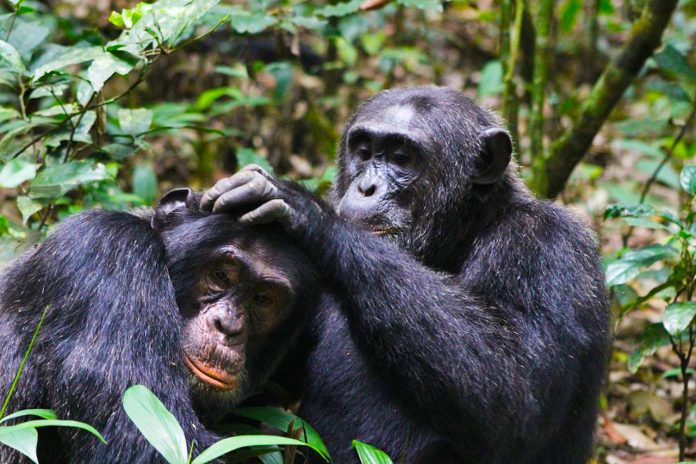
The Ngogo Chimpanzee Project is found in Kibale National Park in Uganda and stands as a beacon of dedication to studying and protecting the Ngogo chimpanzee community. The project was founded in 1995 by David Watts of Yale University and John Mitani from the University of Michigan and has been a hub of scientific inquiry and conservation efforts aimed at understanding and safeguarding these magnificent creatures.
The Ngogo chimpanzee community, renowned for its sheer size and remarkable composition. With nearly 200 individuals, including 32 adult males and 50 adult females, this community represents a scale unprecedented in the chimpanzee world. Such a vast community stands in stark contrast to others within Kibale National Park, where populations typically range from 44 to 60 individuals. Even the largest previously documented community, the Mahlae “M Group,” peaked at 114 members before declining an indication of the exceptional nature of the Ngogo community.
The Ngogo community’s sprawling home range, comparable in size to other chimpanzee communities, harbors a population density three times higher, highlighting the unique ecological dynamics at play in this corner of the park. Researchers at Ngogo are tirelessly unraveling the mysteries behind this phenomenon, exploring various facets of chimpanzee behavior, social dynamics, and ecological interactions.
A key focus of research at Ngogo revolves around chimpanzee feeding ecology, shedding light on the critical role of food availability in shaping community size and density. Unlike other sites within Kibale National Park, where certain tree species are scarce, Ngogo boasts an abundance of essential food sources, particularly the giant fig Ficus mucuso. This tree species, with its year-round fruit production, serves as a lifeline for Ngogo chimpanzees, ensuring a steady food supply throughout the seasons.
In addition to observing chimpanzee behavior, researchers diligently collect biological samples for genetic and hormonal analyses, providing valuable insights into the genetic diversity and health of the Ngogo community. Moreover, the project collaborates closely with local communities and law enforcement agencies to combat illegal hunting, safeguarding chimpanzee populations from external threats.
Researchers at Ngogo also play a pivotal role in the process of habituating chimpanzees for tourism, ensuring that these activities are conducted responsibly to minimize disturbance to the animals and their habitat. By providing financial support for local and government-led conservation efforts, researchers contribute to the long-term protection of chimpanzees and their environment.
Despite the remarkable success of the Ngogo Chimpanzee Project, challenges remain. The historical presence of humans in the area underscores the ongoing need for conservation efforts to preserve these invaluable ecosystems for future generations. As a research site, Ngogo continues to provide invaluable insights into forest ecology and chimpanzee behavior, guiding efforts towards sustainable management practices that protect wildlife and their habitats.
In addition to chimpanzees, Kibale National Park is home to a diverse array of wildlife, including several diurnal and nocturnal primate species. These include red tailed monkeys, blue monkeys, L’hoest’s monkey, red colobus, black and white colobus, baboons, and grey-cheeked mangabeys. Vervets occur along the forest margin and in grasslands in some areas. Nocturnal primates include pottos, Demidov’s dwarf galago, and the eastern needle-clawed bushbaby.
Historically, leopards may have hunted chimpanzees in Kibale, but they are no longer present in the area. Instead, Kibale National Park is home to a diverse range of forest-dwelling animals, including various ungulates like blue duikers, red duikers, bushbucks, and bush pigs, which are potential prey for chimpanzees. Additionally, the forest supports a rich array of rodents, birds, and invertebrates that make up the chimpanzees’ diet.
The park also boasts a sizable population of elephants, which play a significant role in shaping the forest ecosystem. Elephants feed on saplings and small trees, affecting the forest’s structure. Their browsing habits, combined with predation by rodents and insects on seeds and seedlings, can hinder forest regeneration, especially in large gaps.
A gorilla permit is a crucial document issued by government authorities, such as the Uganda Wildlife Authority and the Rwanda Development Board, that enables tourists aged about 15 years and above to trek mountain gorillas in designated habitats. These habitats include Bwindi Impenetrable and Mgahinga in Uganda, as well as Volcanoes in Rwanda and Virunga National Parks in Congo.
The cost of a gorilla permit covers essential services, including the provision of two armed rangers and a guide who accompany trekkers into the jungle, leading them to where these majestic creatures reside. Before venturing into the forest, the gorilla permit is first validated at the park headquarters. Trekkers are then grouped with others before being allocated to their assigned gorilla family.
Once allocated, trekkers are granted one precious hour to spend in the presence of these magnificent creatures. Gorilla trekking involves traversing long distances through the rainforest, searching for gorilla families and enjoying a specified period with them. The duration of this activity can range from 1 to 9 hours, depending on the location of the gorillas, although most tourists typically find them within 3 hours.
In Uganda, gorilla trekking primarily takes place in Bwindi Impenetrable Forest, home to 19 habituated gorilla families, representing almost half of the world’s mountain gorilla population. Additionally, Mgahinga National Park hosts two gorilla groups situated within the Virunga Mountains, straddling the borders of Uganda, Rwanda, and Congo. These habitats extend into Rwanda’s Volcanoes National Park and Congo’s Virunga National Park.
How much is a gorilla permit in Uganda
In Uganda, a gorilla permit costs USD 800 per person per day for tourists. The minimum age requirement for obtaining a gorilla permit is 15 years old. However, there are different rates for certain groups. For foreign residents with work permits, the cost is USD 700 per person, while East African nationals can acquire a permit for UGX 300,000 per person.
The Uganda Wildlife Authority is responsible for issuing gorilla permits, and the price remains consistent regardless of where you purchase it. Special permits may be available on occasion, offering unique opportunities for visitors.
These permits contribute to the conservation efforts aimed at protecting these endangered primates.
How many gorilla permits available in Uganda
In Uganda, there are a total of 192 gorilla permits available for tourists who wish to trek in the Bwindi Impenetrable and Mgahinga National Parks. These permits allow visitors to join one of the 24 gorilla groups inhabiting these parks. However, each gorilla group can only accommodate a maximum of 8 members per day.
With the limited number of permits and the high demand from tourists, it’s crucial to plan ahead. During the peak season, there are often more tourists than available permits. To avoid disappointment, travelers are strongly advised to book their permits 5 to 6 months in advance of their desired tour date.
Gorilla permits can be purchased directly from the Uganda Wildlife Authority (UWA) offices in Kampala, or visitors can opt to use a tour operator to handle the booking process on their behalf.
How gorilla permits are allocated
Gorilla permits in Uganda are allocated based on the specific regions or trailheads where habituated gorilla groups reside within the gorilla parks. In Uganda, there are five main regions designated for gorilla trekking: Buhoma (in the northern section), Nkuringo (in the southern section), Rushaga (in the southwest section), and Ruhija (in the eastern section) within Bwindi Impenetrable Forest, as well as Mgahinga National Park.
When booking a gorilla permit in Uganda, it’s important to specify the region where you prefer to trek mountain gorillas. Unlike Uganda, Rwanda has only one trailhead, and gorilla permits are issued on a first-come, first-serve basis.
Each region offers various accommodation options, so knowing where you’ll stay, eat, and rest is crucial in deciding which region to choose for purchasing your gorilla trekking permit.
Additionally, it’s essential to understand that gorilla permits are not transferable between regions. If a permit is obtained for a specific region, such as Buhoma, it cannot be used for trekking in another region, such as Nkuringo or Rushaga. Therefore, travelers must ensure they book accommodations and plan their itinerary accordingly to match the chosen gorilla trekking region, preventing any wasted permits.
When the gorilla permit expires or you don’t happen to see gorillas
If your gorilla permit expires before you have the chance to trek the mountain gorillas, you unfortunately forfeit the opportunity. However, there is an option to reschedule the permit for another date, provided it’s done at least a week before the original tracking date. After the permit has expired, rescheduling is not permitted by the Uganda Wildlife Authority (UWA).
UWA allows for two reschedules of gorilla permits and the third reschedule requires special approval from the Executive Director and incurs a 25% penalty fee. Rescheduling is possible even if the permit is only partly paid, but for a second reschedule, the permit must be fully paid.
For promotional gorilla permits, rescheduling is only allowed within the promotional period. If rescheduled outside this period, the booker must pay the price difference at the prevailing non-discounted rates.
Gorilla permits in Uganda can be booked up to two years in advance, requiring a minimum 30% deposit at the time of reservation. The balance must be paid less than 90 days before the trekking date. Failure to pay the balance results in the loss of the 30% deposit, and the permit is canceled.
In the event that gorillas are not found during tracking, the Executive Director may authorize rescheduling for the following day, depending on trekking slot availability. If rescheduling is not possible, the Executive Director may authorize cancellation of the permit, with a 50% refund issued upon confirmation by the respective Chief Warden/Warden in Charge of the inability to access gorillas
Gorilla permit cancellation process
If you decide to cancel your gorilla trekking permit, the refund policy varies depending on how far in advance you make the cancellation.
If you request cancellation within eight (8) days of the tracking date, unfortunately, no refunds will be issued by the Uganda Wildlife Authority (UWA).
Cancellation requests made between nine (9) to forty-five (45) days before the tracking date will entitle you to a refund of 25% of the permit value.
For cancellations made between forty-six (46) to ninety (90) days prior to the tracking date, you will receive 50% of the permit value as a refund.
Clients who request cancellation ninety-one (91) days or more before the tracking date will be entitled to a refund of 75% of the permit value. Though it is advisable to do reschedule your gorilla permit since Uganda Revenue Authority doesn’t t usually refund.
It’s important to note these refund policies when considering canceling your gorilla trekking permit, as they are designed to provide some reimbursement based on the timing of the cancellation.
The Sebei, also known as the Sabinyi, are a Southern Nilotic ethnic group found across various countries in East Africa, including Eastern Uganda, Western Kenya, the Democratic Republic of Congo, South Sudan, Ethiopia, and Tanzania. In Uganda, they primarily inhabit three districts for instance; Kapchorwa, Bukwo, and Kween.
Within the Sebei community, there are three distinct but closely related tribes residing in the northern and northwestern regions of Mount Elgon and its surrounding plains. These tribes include the Sebei, Varied on Sabei, and Sapei, which originates from Sapin. Additionally, two other groups known as Sor and the Mbai are part of the Sebei territory.
The Sebei territory shares borders with the Republic of Kenya, which is home to the Kalenjin, a larger ethnic group to which the Sebei belong. This proximity contributes to cultural exchanges and interactions between the Sebei and other neighboring communities. Through their shared heritage and geographic location, the Sebei maintain a rich cultural identity while also embracing connections with neighboring groups.
Language
The Sebei people, also known as the Sabiny, primarily speak a language called Kupsabiny. This language is a dialect of Kalenjin and is also spoken by other smaller groups of Kalenjin descent who live around Mount Elgon. The Sebei, along with these smaller groups, inhabit the hills of Mount Elgon and are collectively referred to as the Sabaot.
Kupsabiny serves as a means of communication and expression within the Sebei community, allowing individuals to connect with one another and preserve their cultural heritage. Through this language, they pass down stories, traditions, and knowledge from generation to generation. It plays a vital role in maintaining the unique identity and unity of the Sebei people and the broader Sabaot community.
Clan and lineage in Sebei culture
In Sebei culture, belonging to a clan is a fundamental aspect of identity. Each Sebei individual is a member of a clan, which is a patrilineal social group characterized by strict exogamy. This means that individuals must marry outside of their own clan. Clan membership holds significant importance in a person’s life, often being the first thing one identifies about another person.
There are approximately 200 separate clans among the Sebei people, with each clan tracing its ancestry back to a single founder. The name of the clan is typically formed by adding the prefix “kap” to the founder’s name. However, some clans have names derived from mythic stories or from particular habits or practices associated with the clan’s founder.
Clans play a crucial role in the spiritual and social lives of Sebei individuals, with members feeling a deep connection to their clan and its traditions. Clans are often believed to have a kind of genetic inheritance of traits, further emphasizing their significance within the community.
Sebei Culture
The Sebei people lead a straightforward way of life, primarily focused on agriculture, livestock rearing, and beer production. Jobs commonly held by the Sebei include tending to cattle and cultivating crops, which vary depending on the region they inhabit. Due to their laid-back culture, the need for elaborate social structures is minimal. The Sebei community is generally peaceful, with few instances of criminal activity.
In Sebei culture, there are two main categories of criminal offenses. The most serious offenses involve murder and physical assault, while lower-level offenses may include property disputes or civil conflicts between individuals or groups. Additionally, as a rite of passage, teenage boys and girls undergo circumcision ceremonies within the Sebei community.
Ritual transformation into adulthood in Sebei
In the Sebei culture, the transition from adolescence to adulthood is marked by several ceremonial activities that hold great significance. These ceremonies typically span a period of 1 to 6 months and are a crucial rite of passage for both boys and girls. Boys usually undergo initiation between the ages of 18 to 20, while girls typically participate at a slightly younger age.
Central to these ceremonies is the circumcision of boys, a significant event that symbolizes their transition into manhood. For girls, the counterpart operation involves the complete removal of the labia minora, a procedure known locally as circumcision but more accurately termed labiaectomy or female genital mutilation.
Alongside these primary procedures, there are other ceremonial activities that form part of the initiation process. These may include painting, shaving, and the partial lifting of taboos associated with seclusion.
Female genital mutilation
The Sabiny people of Kapchorwa District in Uganda are known for their practice of female genital mutilation (FGM), also referred to as female circumcision. Traditionally, Sabiny girls are expected to undergo this procedure shortly after reaching puberty, but before marriage. It is believed that removing the clitoris reduces the temptation for promiscuity. Those who refuse to undergo the procedure are socially ostracized, forbidden from marrying, speaking to circumcised women, or undertaking certain tasks considered exclusive to women.
FGM ceremonies typically occur in December of every even-numbered year. During these communal events, several girls undergo the procedure, which lasts for several days. The actual operation, which only takes a few minutes, involves slicing off the clitoris and part of the labia minora. The procedure is performed without anesthesia or disinfectant, using non-sterilized knives, razors, or even sharp metal or glass. Girls are expected to endure the pain silently, as crying out is seen as cowardice.
Short-term complications of FGM include urinary retention, hemorrhaging, and temporary lameness. In the long term, women often experience extreme pain during sexual intercourse and have an increased risk of childbirth complications. Some may even die from the procedure or suffer from HIV transmission and other sexually transmitted diseases due to vaginal tearing.
Public debates about FGM are traditionally taboo, but efforts to eradicate the practice have gained momentum in recent years. In 2010, Uganda made it illegal to carry out or participate in FGM-related events. Despite opposition from traditionalists, President Yoweri Museveni’s government has been committed to abolishing FGM and promoting women’s rights.Jane Francis Kuka, a local educator, was one of the first to openly oppose FGM in the 1970s. She faced strong opposition from community leaders but persisted in her efforts. The formation of the Sabiny Elders Association in 1992 marked a breakthrough in the campaign against FGM, aiming to preserve positive cultural practices while eliminating harmful traditions like FGM.
Despite these efforts, some Sabiny traditionalists still view FGM as integral to their cultural identity. Uncircumcised women may face social discrimination, while those who perform FGM, particularly female elders, maintain their elevated status in the community.
Overall, while progress has been made in the fight against FGM in Uganda, continued efforts are needed to fully eradicate this harmful practice and promote gender equality and women’s rights.
Tourist attractions around the Sabiny people
Kapchorwa District in Uganda stands out as a premier destination for tourists as the place offers opportunities to discover natural attractions.
Mount Elgon national park
Mount Elgon National Park, situated northeast of Lake Victoria, spans across both Kenya and Uganda. It is home to Africa’s eighth-highest massif, Wagagai Peak, standing at 4,321 meters. The park boasts diverse flora and fauna, and its lower slopes outside the national park feature the renowned Sipi Falls, a popular tourist destination in the Elgon region.
Notably, Mount Elgon National Park is unique in that it straddles the border between Kenya and Uganda, creating a shared space between the two countries. This mountain serves as a crucial water catchment area for two major rivers: the Nzoia River, which flows towards Lake Victoria, and the Turkwel River (also known as the Suam River in Uganda), contributing water to Lake Turkana. The park’s resources play a vital role in sustaining the water supply in the surrounding regions.
During a safari to Sabiny land, visitors can explore nearby attractions such as the Pian-Upe Wildlife Reserve and Kidepo Valley National Park in Nakapiripirit district to the north. These protected areas are home to some of Uganda’s endangered species, including ostriches, cheetahs, hyenas, leopards, lions, elephants, and elands. Additionally, visitors have the opportunity to engage with local communities around the protected areas. Besides the Sebei – Sabiny culture, Uganda is multicultural so don’t miss out these neighboring communities like Bamasaba people, the Karamojong people and the Batwa people around Bwindi impenetrable and Mgahinga National park.
Dolwe Island rock art, also known as Lolwe or Lolui Island, is situated in the eastern part of Uganda, in the northeastern region of Lake Victoria within the Busoga region, specifically in Namayingo district. Covering an area of 25 square kilometers, this island has been in existence for approximately 300-500 years.
The landscape of Dolwe Island is characterized by granite rocks and boulders, which dominate the scenery. These natural formations have long-aged rock art designs etched into them, offering a glimpse into the island’s mysterious past. Among these designs are rock paintings, carvings, engravings, and rock gongs, which serve as valuable cultural artifacts providing insights into the beliefs, customs, daily life, and history of the early inhabitants.
Although Dolwe Island’s rock art is not as widely recognized as other sites like Nyero Rock Point, it is endowed with unique archaeological features that contribute to our understanding of the island’s heritage.
Dolwe Island boasts a unique feature as it has thousands of ground depressions carved into its granite slabs. These intricate carvings, often found in remote and inaccessible locations, suggest a ritual or spiritual significance rather than a purely practical one.
Despite its mystical charm, Dolwe Island is home to a community of approximately 10,000 people, with half residing in the town of Golofa. The island’s rugged terrain lacks roads and vehicles, but skilled Boda boda riders navigate sandy paths with ease. Fishing is the primary economic activity, with Nile perch and tilapia being the prized catches in Lake Victoria’s waters.
Standing on the shores of Dolwe Island, overlooking Lake Victoria’s vast expanse, one feels a profound sense of tranquility. The calm blue waters, adorned with sails, offer a peaceful retreat from the mainland’s hustle and bustle.
History of Dolwe Island rock art
Dolwe Island, nestled in the northeastern corner of Lake Victoria within the Busoga region, holds a rich history dating back to the early 20th century. While the Basoga people, native to the region, did not settle on the island due to their lack of fishing traditions, it became home to various communities over the years.
According to oral history, the first inhabitants of Dolwe Island were the Bavuma people from Buvuma Island in 1904. They sought refuge on Dolwe Island after being chased from Buvuma due to a conflict with their king, Kabaka Daudi Chwa II of Buganda. This relocation was part of a broader pattern of resistance against British colonial forces, who forcibly displaced communities to areas free from the tsetse fly, which spread sleeping sickness.
Despite the initial settlement, Dolwe Island faced challenges, including outbreaks of sleeping sickness in the 1920s and 1954, leading to the evacuation of many residents. These disruptions likely contributed to the loss of oral traditions and knowledge of earlier inhabitants.
Nevertheless, Dolwe Island remains a site of cultural and natural significance, boasting rock art sites and other heritage resources. These include Bugire Site 1 (Golofa) and Kandege Site 2, documented by various researchers over the years. Excavations at Bugire 1 revealed artifacts spanning different periods of the Iron Age, shedding light on the island’s past inhabitants.
In recent years, efforts to preserve and manage Dolwe Island’s heritage have intensified. The Uganda Department of Museums and Monuments, in collaboration with organizations like TARA, conducted systematic surveys to record rock paintings, gongs, and engravings on the island. Additionally, the installation of amenities such as cemented ladders and signage aims to enhance accessibility and visitor experience while ensuring proper management and conservation.
How to access Dolwe Island rock art
Accessible via an approximately 5-hour journey by road from Uganda’s capital city, Kampala, or a swift speed boat ride from the main landing site of Bwondha, Dolwe Island offers a tranquil escape from the hustle and bustle of city life.
To reach Dolwe Island from the town of Jinja, travelers can embark on a 25-kilometer drive east towards Iganga town before turning off the highway at Musita trading center. From there, a 54-kilometer drive on a currently under-construction road leads to Mayuge district, followed by another 42 kilometers to Bwondha landing site in Namayingo district.
Once at Bwondha landing site, visitors can board a boat or canoe, depending on availability and affordability, for the journey to Dolwe Island. Private speed boats typically take around 1½ hours, while public boats, which cater to commuters traveling to various islands on the lake, may take a bit longer.
Efforts are underway to advocate for the introduction of a government ferry to facilitate easier transportation of people, goods, and services to and from the island.
The Pearl of Africa Tourism Expo (POATE) was launched by Uganda Tourism Board (UTB) in 2017. Over the years, POATE has become a major travel trade show in East Africa for business to business (B2B) and business to consumer (B2C). The 8th edition of POATE is scheduled to start on 23rd and end on 25th May at the Speke Resort and Convention Centre Munyonyo in Kampala.
The state-of-the-art facility has 200 meeting rooms, 20 boardrooms, 447 accommodation rooms, and 6 outdoor venues. Given its unique location on shores of Lake Victoria, the venue has a tranquil environment for meetings, incentives, conferences, and events (MICE). The event is organised by UTB in partnership with the Ministry of Tourism Wildlife and Antiquities (MTWA), the private sector among other local stakeholders.
Opportunities for trade visitors, local, and international exhibitors intending to take part in the event are available for booking through UTB head offices in Kampala. Over 70 travel business professionals (hosted buyers) and 5,000 trade visitors are invited to attend. POATE offers an opportunity to network and showcase your travel, tourism and hospitality products and services to a potential business partner or client in a safe face-to-face environment.
“Responsible Tourism” is the theme for this year’s Expo and the intention is to create awareness among the various stakeholders about the meaning of the topic. As one of the biggest industries in the global economy, international tourism was projected to reach 90% of pre-Covid-19 pandemic levels by 2024. According to UN Tourism, $1.4 trillion was generated in 2023 which is almost 93% of the $1.5 trillion earned in 2019.
Tourism in Uganda is a fundamental pillar driving economic growth. According to the MTWA Annual Tourism Performance Report FY 2023, tourist arrivals have recovered by 56% after the pandemic from 814,508 in 2022 to 1,272,210 in 2023. The sector generated over $1 billion compared to $ 1.453 billion as foreign exchange in 2017-2018.
As tourism is growing rapidly, it is also causing negative impacts including habitat loss, environmental degradation, deterioration of authenticity among local cultures. Responsible tourism is a branch of tourism that attempts to minimize the negative impact by doing the right stuff. The best way to put responsible tourism into practice requires careful planning and management of tourism by all stakeholders at all levels.
There are several ways that people and organizations in the tourism sector can exhibit responsible behavior. For instance, preserving the natural environment and culture and heritage, hiring local staff, involving local communities in decision making, use of ethical marketing and promotion, corporate social responsibility, and use of eco-friendly products. As such, POATE is offering an opportunity to learn how tourism can promote the sustainable development goals.
Examples of responsible tourism in Uganda include environmental clean-up campaigns that are done by several organisations including the Miss Tourism Uganda and the Uganda Lodges.
Some of the local communities around several national parks are also benefiting from direct involvement with lodges. For instance, the Clouds Mountain Gorilla Lodge in Nkuringo sector in southern Bwindi is actually owned by the community and managed by private lease holders.
Given the high-end nature of the lodge, the resources transferred to the community are very significant, in addition to the staff, food and furnishings which can be sourced locally. Many other lodges also generate modest benefits for the surrounding communities including Nkuringo Bwindi Gorilla Lodge. This is a carbon neutral lodge that works with the Uganda Carbon Bureau to offset its carbon footprint through several projects which include indigenous tree planting, rain water harvesting, pack for a purpose and fair trade policy.
There’s also Uganda Wildlife Authority’s experiential tourism activities that you can do on safari such as lion tracking in Queen Elizabeth national park. These few examples show how Uganda is adapting to the travel trend where there’s a shift from traditional safaris of sun, sea and sand towards the experiential travel which aligns with the sustainable development agenda.
Uganda offers a wide range of tourist attractions of which the most notable are the mountain gorillas in Bwindi and Mgahinga gorilla national parks. These rare endangered primates can only be found in Uganda, Rwanda and DR Congo. Primates give Uganda a competitive advantage through gorilla trekking tours over the game viewing safaris which are dominated by Kenya, Tanzania and South Africa.
In addition to the primates, Uganda also offers 10 national parks, 13 wildlife reserves, and an impressive variety of bird species estimated at over 1073 species, the source of the Nile at Jinja with adventure tourism, whitewater rafting, and bungee jumping. The spectacular Rwenzori Mountains offer multiple-day trekking, beautiful lakes, rich cultural and historical heritage and night life round out the picture. Thus, Uganda offers tours of one or two weeks which combine primate trekking, mountain climbing, adventure, and game viewing.
The Buganda kingdom is the largest of Uganda’s traditional, medieval, and subnational kingdoms. It was established in the late 14th century along the shores of Lake Victoria and grew to become an important and powerful state during the 19th century. Geographically, the Buganda kingdom is surrounded by Lake Victoria to the south, the River Nile to the east, Lake Kyoga to the north, the River Kafu to the northwest, and the districts of Masindi, Hoima, Kibale, Kyenjojo, Isingiro, and Kiruhura to the west.
The Buganda kingdom comprises all 26 districts of Uganda’s Central Region, including the Ugandan capital city, Kampala. It is divided into 18 officially recognized counties known as “masaza”. Each county is further divided into sub-counties called gombolola, which are then divided into parishes known as Miluka (singular: muluka). These parishes consist of two villages.
The kingdom is predominantly made up of Uganda’s largest ethnic group, the Baganda, who represent 16.9% of the country’s population. The Baganda (singular: Muganda) are sometimes referred to as the “king’s men” due to their significance and the roles they play in the kingdom’s political, cultural, and social institutions.
History of Buganda kingdom
The Buganda kingdom is among several kingdoms that emerged after the fall of the Chwezi empire. It was established in the northwest part of Lake Victoria and east of Bunyoro, between Lake Kyoga and Lake Albert. The Baganda people are thought to have originated from Bantu clans that migrated from the Congo Basin, while others came from Eastern Uganda. Some clans of the Buganda kingdom are said to have originated from the Ssese Islands and settled in present-day Busiro, Mawokota, and Kyadondo.
The kingdom’s origin is not entirely clear, but various theories have been proposed. According to oral tradition, the kingdom was founded by Kabaka Kintu, whose origins are uncertain. Traditional legends suggest he came from the northeast, descended from heaven via Bunyoro. Perhaps most credibly, it’s believed he arrived in Buganda from beyond Mount Elgon, suggesting an origin in Sudan or Ethiopia. Kabaka Kintu came to power after defeating the local ruler named Bemba Musota and declared himself the head of all clans, known as Ssaabataka. He took over a house in Naggalabi Buddo, 20 km from Kampala, as a symbol of victory. This house was called Buganda, a name later transferred to the entire territory ruled by Kintu. Naggalabi Buddo remains the coronation site of the Kabaka to this day.
According to Bunyoro tradition, the founder of the Buganda kingdom was Kato Kimera, who came from Bunyoro and is believed to be a brother to Rukidi Mpuga, the founder of the Babito dynasty. It’s believed that Kato Kimera carved out Buganda from the collapsing Bunyoro-Kitara kingdom. King Kato Kimera is said to have brought with him five to six present-day clans of Buganda. After Kintu, 36 kings followed, but they all mysteriously disappeared after laying the foundation of Buganda.
In the early centuries, the kings ruled under the influence of clan heads. By the year 1700, the Buganda kingdom had gained more control over its territories. Initially, the kingdom consisted of only Busiro, Mawokota, and Kyadondo around the 15th century.
During the 16th century, Buganda started to expand its land by conquering several chiefdoms, which increased the number of provinces to 12 by 1890. The newly acquired lands were placed under chiefs chosen by the king. The Buganda army and royal tax collectors were able to quickly move to different parts of the kingdom.
By the 17th century, Buganda had grown to include Singo, Gomba, and Butambala under Kabaka Katerega, who took these areas from the Bunyoro kingdom. Under Kabaka Jjunju, Buganda expanded further to include Buddu and Kooki, which were taken from the Ankole kingdom. By the middle of the 19th century, Kabaka Mawanda had captured the counties of Bulemeezi, Kyaggwe, and Bugerere, making Buganda the largest kingdom in the interlacustrine region at that time.
In 1900, following the Buganda agreement, with the help of the British, Kabaka Muteesa brought in the lost counties of Buyaga, Bugangaizi, and Buluri as a reward for their collaboration with the British in crushing Bunyoro.
Language
The Luganda language is widely spoken in the Buganda kingdom and is the second most popular language used in Uganda, alongside English. Before Uganda gained independence in 1962, Luganda was also used as a means of instruction in schools outside the Buganda kingdom. Previously, local languages were taught in schools until new curricula were introduced.
In literature and everyday conversations, the Buganda kingdom is often referred to as central Uganda because Uganda’s capital city is located within Buganda. This geographical association reflects the central role that Buganda plays within the country, both historically and in contemporary times.
Social structure of Buganda kingdom
The King’s Palace was typically situated on a hill, and upon his passing, this hill would become his final resting place. His successor would then select a new hill for his own palace. Within the King’s Palace were numerous household compounds where his many wives, pages, and chiefs lived. They were all required to spend considerable time in the Kabaka’s palace to show their allegiance to him.
In Ganda society, social organization focused on tracing ancestry through males. A patrilineage comprised four or five generations of descendants linked through male ancestors. These patrilineages formed clans, and clan leaders could convene a council of lineage heads whose decisions affected all lineages within the clan. Many decisions, especially those concerning marriage, were regulated by these councils, as marriages between different lineages formed significant social and political alliances for men.
Leaders of lineages and clans also played a role in maintaining effective land use practices and fostering pride within the community through ceremonies and honoring ancestors.
While many lineages maintained ties to a designated home territory, known as butaka, within their respective clan territories, not all members exclusively resided on butaka land. Typically, men from one lineage formed the nucleus of a village, with their families and in-laws joining them. People had the freedom to leave if they became dissatisfied with the local leader, often relocating to live with other relatives or in-laws.
Religion
The Kiganda religion is the traditional belief system of the Buganda kingdom. It’s essentially animist, meaning its followers believe in serving various ancestral and other spirits rather than a single supreme being. In this religion, temples dedicated to the most powerful spirits are present, each served by a medium and a hereditary priest. These priests play crucial roles in both religious and political matters. Even the most powerful kabaka, or king, would consult with the appropriate spirit mediums before making important decisions or engaging in battles.
The kabaka would appoint at least one female slave or relative to take care of each shrine. These caretakers would provide food and drinks to the shrine’s priest and medium. This shows the importance of these spiritual practices within the Buganda kingdom’s social and political structure.
Political structure of Buganda Kingdom
The Buganda Kingdom is ruled by a Kabaka, an autocratic monarch whose position is passed down through hereditary status and is not confined to any single clan. The Kabaka would marry into as many clans as possible, and one-tenth of these marriages would involve members of the royal harem. The heir of the Kabaka would take the clan of his mother, a custom designed to foster loyalty to the throne. Each of the 52 clans in Buganda could hope to one day produce a king, which encouraged allegiance to the monarchy.
Traditionally, Kabaka Muteesa, who was on the throne when Speke arrived in Buganda in 1862, is listed as the 30th Kabaka. The current Kabaka of Buganda is Kabaka Ronald Muwenda Mutebi II, the 36th Kabaka, who has ruled since the restoration of the kingdom in 1993. The head of the Buganda government is the Katikkiro (prime minister), currently Charles Peter Mayiga, appointed by the Kabaka in 2013. The Buganda parliament is known as the Lukiiko.
Before the Buganda Agreement of 1900,the Buganda Kingdom traditionally allowed for some upward and downward mobility. Any talented person could rise to social prominence, but it was nevertheless strongly stratified with three distinctive classes recognized. The highest class was the hereditary Balangira clan (aristocracy), which based its right to rule on royal blood. In addition to the Kabaka, several aristocratic figureheads were recognized, including the Namasole (queen mother), Lubuga (king’s sister), and Katikkiro (prime minister). Other individuals who held positions of political and social importance were Gabunga and Mujasi, the respective commanders of the royal navy and army.
The middle class in Buganda society consisted of chiefs or Baami. At first, only the Bataka, who were clan heads, held the hereditary status of the Baami. After 1750, however, Bakopi men could be promoted by royal appointment to Baami status based on distinguished service and ability. A hierarchical system of chieftaincy existed, corresponding with the importance of the political unit over which any given chief held sway. The most important administrative division was the Saza (county), each of which was ruled by a Saza chief. These were further subdivided into Gombolola (sub counties), then into parishes and sub-parishes, and finally into Bakungu, which were more or less village units. The Kabaka could choose to hire or fire any chief whenever he wanted, and every level of Baami had to answer directly to him. They were also responsible for maintaining internal security, overseeing royal estates, and serving in the kingdom’s military. This provided a defensive force as well as a mechanism for invasion of neighboring kingdoms to steal ivory, women and slaves. The 1900 Buganda Agreement shifted power to the Lukiiko, which previously functioned as an advisory council, at the expense of the Kabaka.
At the bottom of the social strata was the serf class known as the Bakopi, literally “the people who don’t matter.” The Bakopi were subsistence farmers whose labor formed the base of Buganda’s agricultural economy. Many Bakopi cultivated local staples like bananas, supplemented by sweet potatoes, beans, cassava, and green vegetables. The Bakopi relied on farming the land for their livelihood, but they didn’t have any ownership rights to it. All land in Buganda was the property of the Kabaka, who could allocate the right of usage to any subsidiary chief at whim. The chiefs, in turn, allocated their designated quota of land as they deemed fit, a scenario that encouraged obedience among the Bakopi. During Kabaka Suuna’s illness, it’s said that he ordered 100 peasant men and women to be sacrificed every day until he got better.
Buganda retained self-government within the larger Uganda protectorate but was subject to formal British oversight. The 1995 Buganda Agreement transformed Buganda from an absolute to a constitutional monarchy. During Uganda’s independence, debates arose over Buganda’s constitutional position and its ability to remain self-governing. This led to discussions and agreements, such as the Buganda Agreement of 1961 and the first constitution of Uganda in 1962, granting Buganda a high degree of autonomy.
However, this autonomy was revoked during Obote 1’s regime in 1966, and kingship and the Lukiiko were abolished in 1967. The kingdom was later restored in 1993.
Today, the Kabaka holds only ritual functions and has no political power. He was stripped of his power to prevent tribal differences from disrupting the formation of a unified nation state. Presently, Baganda holds differing beliefs about the Kabaka’s role in the nation state. However, all Baganda participate in the Ugandan governmental system, which comprises 39 districts and a national president. These districts encompass separate units that were once part of the Kingdom of Buganda.